Introduction
You walk outside one morning to find your lawn covered in brightly colored lines and flags—red, yellow, blue, orange—painted across the grass and sidewalk. Most people are puzzled by this overnight appearance, but these markings are far from random. They represent a critical safety language used across every construction and excavation project in the United States.
This guide decodes the full system: what every color means under the APWA Uniform Color Code, how to read symbols and numbers beyond just colors, and what safety steps apply before any digging begins.
Two distinct marking systems exist—underground utility markings and roadway/pavement markings—and this guide covers both.
Key Takeaways
- Construction markings identify underground utilities or direct traffic using standardized color codes
- APWA's eight-color system covers utilities from electric (red) and gas (yellow) to water (blue), sewer (green), and survey markers (pink)
- Roadway markings use white for same-direction traffic and yellow for opposing traffic
- Symbols, letters, and numbers on markings encode depth, utility owner, and dig boundaries
- Call 811 at least 48–72 hours before excavating — it's free, fast, and legally required in all 50 states
Why Construction Markings Exist: The Safety Case
The 1976 Culver City Catalyst
On June 16, 1976, a street-widening project on Venice Boulevard in Culver City, California, became a turning point for construction safety. A piece of equipment struck an 8-inch high-pressure petroleum pipeline, spraying gasoline onto nearby buildings. The fuel ignited 90 seconds later, killing 9 people, injuring 14 others, and destroying 7 buildings.
The National Transportation Safety Board investigation revealed a critical failure: while the contractor and pipeline owner knew the pipeline existed, its precise depth and location were unknown. More significantly, no one-call notification system was in effect in the Los Angeles area at the time. This tragedy directly prompted federal recommendations for utility owners to join or organize one-call systems.
The 50-Million-Mile Underground Network
The U.S. subsurface infrastructure is far larger than most people realize. Approximately 50 million miles of buried pipelines, cables, and facilities exist beneath American soil—more than double the 20-million-mile estimate used throughout the 1990s. That number keeps climbing as communities grow and aging infrastructure gets replaced or expanded. With that much buried beneath us, the margin for error during any excavation is razor-thin.
The Cost of Utility Strikes
Despite decades of safety improvements, excavation damages remain frequent and costly:
| Metric | Figure | Context |
|---|---|---|
| Annual Damages | 196,977 | Unique utility strikes reported in 2024 |
| Annual Societal Cost | $30 Billion | Including repair, property damage, medical expenses, and business closures |
| Historical Casualties | 141 Deaths, 440 Injuries | From 1,630 significant third-party excavation incidents (1993-2012) |
The American Public Works Association developed the Uniform Color Code specifically to prevent these tragedies. Later formalized by the American National Standards Institute as ANSI Z535.1-2022, the standard gives every excavator a consistent visual system — so a contractor in Pennsylvania reads the same markings the same way as one in California. That shared language is what makes pre-dig communication reliable instead of assumed.
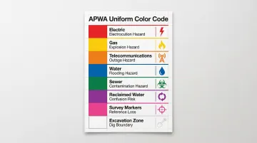
The APWA Utility Color Code System Explained
The APWA Uniform Color Code assigns eight specific colors to underground infrastructure types. These colors appear as spray paint markings on hard surfaces and colored flags in yards or soft ground.
Knowing what each color means before breaking ground can be the difference between a routine dig and a catastrophic strike. Here's what each color signals:
| Color | Utility Type | Primary Hazard |
|---|---|---|
| Red | Electric power lines & conduit | Electrocution, arc flash, fire |
| Yellow | Gas, oil, steam, petroleum | Explosion, fire |
| Orange | Communication & fiber optic lines | Emergency service outage |
| Blue | Potable water lines | Flooding, contamination |
| Green | Sanitary sewers & drains | Raw sewage, environmental hazard |
| Purple | Reclaimed water & irrigation | Confusion with potable water |
| Pink | Temporary survey markings | Boundary/elevation reference loss |
| White | Proposed excavation area | Dig zone communication |
Color-by-Color Breakdown
Red — Electric Power Lines Electric power lines, cables, conduit, and lighting cables all get red. Striking an energized line creates immediate life-threatening danger from electrocution, arc flash, or fire. Red markings demand the highest caution level on any site.
Yellow — Gas, Oil, and Petroleum Gas, oil, steam, petroleum, and other flammable materials are marked yellow. Damaging these lines risks explosions and fires. The 1976 Culver City disaster involved a yellow-coded petroleum line — a real-world reminder of why yellow zones require extreme care.
Orange — Communication Lines Alarm cables, fiber optic lines, telecommunication conduit, and signal lines all fall under orange. A single strike here can knock out internet, phone service, and emergency communications for entire communities — the safety consequences extend well beyond the job site.
Blue — Potable Water Blue marks drinking water lines. Strikes cause flooding and water service loss, and if soil or debris enters a broken line, contamination risks follow. Neighborhoods can lose safe water access until repairs are complete.
Green — Sanitary Sewers Sewer lines and drain lines are marked green. Breaching one creates environmental hazards and direct public health risks from raw sewage exposure.
Purple — Reclaimed Water Treated wastewater reused for irrigation or industrial purposes gets its own color: purple. Because reclaimed water is not safe for drinking, the distinct marking prevents workers from confusing it with potable blue lines.
Pink — Temporary Survey Markings Pink flags or paint mark temporary survey points — boundaries, elevations, or reference points established for the project. These are placed by surveyors and should not be disturbed during excavation.
White — Proposed Excavation Area White defines the planned dig zone. The excavator or contractor places white markings before utility locators arrive, communicating exactly where underground utilities need to be checked. White tells locators where to look — not what's there.
Reading Construction Marking Symbols, Numbers, and Flags
Color tells you what utility is present, but shapes and symbols add precision. Understanding these details helps excavators identify exact boundaries and safe digging zones.
Marking Symbols and Shapes
Single Line (Centerline): A single mark placed over the approximate center of the utility indicates its general path.
H-Marks (Outside Edges): Marks placed over the approximate outside edges of a wider utility with a line connecting them (forming an "H") show the full width of the facility.
Diamond (Conduit): Marks over the outer extremities with a diamond connecting the horizontal lines indicate facilities carried inside conduits or ducts.
Offset Markings: When direct marking isn't possible due to landscaping or pavement, marks are placed parallel to the line with an arrow pointing toward the facility and indicating distance (e.g., "8' OFFSET").
Abbreviations and Depth Indicators
Locators include critical information beyond color:
- Company initials (e.g., TELCO, GASCO) identify who owns the line
- Material descriptions such as STL (steel), PLA (plastic), FO (fiber optic)
- Pressure indicators like HP (high pressure)
- Depth measurements in feet or inches from the surface
- Facility count when multiple lines run in the same corridor
Flags as Physical Markers
Flags serve as the physical counterpart to spray paint on grass, gravel, or surfaces where paint won't adhere. They carry the same color-coding system and often include written information from the utility locator—company name, utility type, and depth.
Keeping those markings visible throughout a project requires products built to last on-site. RE&D supplies underground detectable tape, marking flags, and custom safety signs to construction teams who need compliant, durable identification solutions.
Types of Roadway Markings
On any active job site or public road near a construction zone, roadway pavement markings are a separate system from utility markings. Where utility colors identify what's buried underground, roadway markings guide vehicle and pedestrian traffic above ground — and they're governed by the Federal Highway Administration's Manual on Uniform Traffic Control Devices (MUTCD), 11th Edition.
White Pavement Markings
White markings manage same-direction traffic:
- Lane lines dividing traffic traveling the same direction
- Edge lines marking the right-hand roadway edge
- Crosswalks for pedestrian safety
- Stop bars at intersections
- Turn arrows indicating permitted movements
- Speed limit markings painted on pavement
Yellow Pavement Markings
Yellow markings separate opposing traffic flows:
- Center lines on two-way roads
- No-passing zones in areas with limited visibility
- Left-hand edge lines on divided highways
- Two-way left-turn lane boundaries
Orange in Construction Zones
Orange is designated for temporary traffic control under MUTCD Part 6. In and around active work zones, you'll see orange used for:
- Warning signs alerting drivers to changing road conditions ahead
- Channelizing devices such as cones, drums, and barriers redirecting traffic flow
- Temporary pavement markings that override standard lane configurations during construction
Other Roadway Markings
- Raised Pavement Markers (RPMs) supplement painted lines with reflective visibility, especially useful in low-light or wet conditions
- Rumble Strips use grooved patterns along shoulders or centerlines to create audible and tactile alerts when drivers drift out of their lane
- Temporary Markings redirect traffic safely around work zones during construction, typically removed or covered once permanent markings are restored
Construction Site Safety: Best Practices Before and During Digging
The 811 Call Before You Dig Process
In 2005, the Federal Communications Commission designated 811 as the national abbreviated dialing code for excavation notifications. All 50 U.S. states and the District of Columbia legally require excavators to contact the one-call center before digging.
How it works:
- Call 811 or submit online at least 48-72 hours before excavation
- Describe your project including location and scope
- Wait for locators to visit and mark utilities
- Receive clearance before beginning work
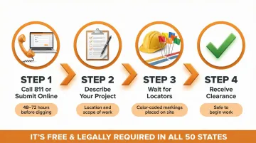
This service is free and triggers utility companies to send locators who place color-coded markings on your site.
What Happens During the Locate Window
Utility locators visit the site using detection equipment—including ground-penetrating radar and electromagnetic locating tools—to place physical markings showing where underground facilities exist.
Critical limitation: Maps and diagrams alone can't guarantee accuracy. Utility records are frequently outdated or incomplete, which is exactly why physical locates are non-negotiable.
Root Causes of Utility Strikes
Despite the 811 system, 24.54% of all utility strikes in 2024 were caused by failure to notify 811. Many excavators falsely assume shallow residential digs are exempt.
Other leading causes include:
- Excavator failed to maintain clearance (16.07%)
- Facility not marked due to locator error (11.94%)
- Marked inaccurately due to locator error (8.58%)
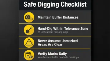
Safe Digging Practices
Once markings are in place:
- Maintain required buffer distances from each marking before using mechanical equipment
- Hand-dig within the tolerance zone—typically 24 inches from the outside edge of markings
- Never assume a marking has been placed if you didn't request a locate
- Verify marks before starting work each day, as weather and traffic can fade them
If You Discover Unmarked Utilities
Stop work immediately. Do not attempt to move or repair the line. Contact the utility owner and follow site emergency protocols. Utility strikes carry a steep price: Common Ground Alliance data puts average incident costs—covering property damage, fines, and project downtime—well above $5,000, and that figure doesn't account for injury liability.
Frequently Asked Questions
What are construction markings?
Construction markings are color-coded paint lines, flags, or stakes placed on the ground to indicate underground utility locations or direct traffic on roadways. They use a standardized system set by the APWA for utilities and the MUTCD for roadway traffic control.
What do the color codes for construction markings mean?
The APWA color code assigns: red = electric, yellow = gas/oil, orange = telecom, blue = water, green = sewer, purple = reclaimed water, pink = temporary survey, and white = proposed excavation area.
What are the types of roadway markings?
The two main types are white markings (same-direction lane divisions, crosswalks, stop bars) and yellow markings (opposing traffic separation, no-passing zones). Governed by the MUTCD, they serve traffic management rather than utility identification.
What does white spray paint mean on pavement at a construction site?
White paint at a construction or excavation site marks the proposed dig area—placed by the contractor to show utility locators exactly where digging will occur. On public roads, white paint also serves standard traffic lane marking purposes.
How long do construction utility markings last?
Utility markings are temporary. Spray paint typically lasts a few weeks depending on weather and traffic, while flags may be removed sooner. Excavation should occur within the validity window of the locate ticket, which varies by state (typically 10–30 days).
Do I need to call 811 even for small digging projects?
Yes, 811 is required for any excavation regardless of depth or project size—even planting trees or installing fence posts. Underground utilities can be as shallow as a few inches, making any unlocated digging potentially dangerous and illegal.